The Hype
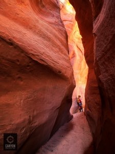
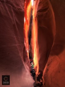
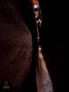
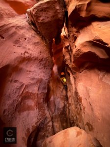
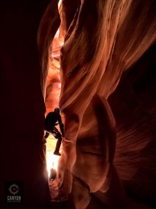
While the name may not evoke much positive emotion, this canyon is a stunning wingate slot that is short, sweet, and very photogenic. The slot is characterized by aesthetic squeezes, beautiful chambers, and long slanted narrows.
The first known descent of the canyon was done by Bill Wolverton and Steve Cole. The name Sad Cow Disease was coined later by a team who descended the slot on Mother’s Day to find a mother cow and her calf deceased in it’s lower reaches, as well as in Little Death Hollow. As of May 2013, a few bones and cow skull remain at the mouth of the canyon.
From Eric Godfrey:
A big dead cow in the middle of the slot. With my face inside my shirt, I basically ran toward it, stemmed over it, and kept running to get away from the smell. But mom wasn’t the only one who died, behind her was the corpse of her calf, who stuck with her till the end. We were all pretty traumatized by the smell but Jenny was a bit traumatized by the scene of mother and baby, thus the name of the canyon. Click to expand…
Getting There
Access Road:
The Little Death Hollow Trailhead is located on the Wolverine Loop road, south of the Burr Trail. Best accessed from Boulder, Utah, the trailhead is typically accessible to regular passenger vehicles in dry conditions. Please check current road conditions with the Escalante Interagency Visitor Center at 435-826-5499 as the conditions vary from storm to storm. The last stretch of road runs in and out of a wash bottom so if it has rained, it could easily become high clearance 4WD or even impassable.
To reach the trailhead, drive east from Boulder, Utah on The Burr Trail for approximately 18.5 miles to a signed turnoff for the Wolverine Road (37.924265,-111.220581). The road is paved until this point. After leaving the Burr Trail, stay on the main Wolverine Road for approximately 13 miles to the signed turnoff to the Little Death Hollow Trailhead (37.784069,-111.180447). If you are dropping off a car at the Wolverine Trailhead (37.803829,-111.206696) for the point-to-point version of the hike, you will pass it about 2.5 miles before arriving at the LDH Trailhead. You may also spot a car near either of the next two canyons if you prefer to exit through one of them, see the maps tab for more information.
For more information on hiking and backpacking in the Little Death Hollow area, please visit the Little Death Hollow Trail Guide at Backcountrypost.com
Driving Map:
Driving directions from Boulder, UT to Little Death Hollow Trailhead
From the Trailhead:Begin hiking downcanyon from the trailhead descending a fairly wide open and exposed drainage. After a couple miles, the Wingate walls of Little Death Hollow will begin to close in, and you’ll find yourself in the first hint of narrows. Approximately 3.75 miles from the trailhead, you will arrive at a break in the cliffs to the north. This crack and slab system needs to be climbed to gain the bench that will give access to the head of the canyon. The climb goes at 3rd or 4th class, and should never be too exposed if you pick your route carefully. Coordinates: 37.754674, -111.217749
Once on top of the bench, contour the wingate rim for approximately 30 more minutes and find your way to the first drop of the canyon.
The Canyon
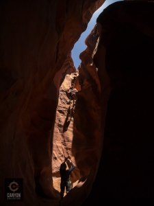
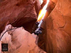
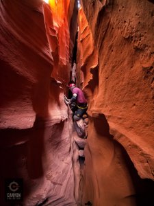
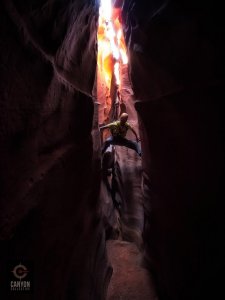
Skills required: Sad Cow is a canyon that is somewhat remote and requires advanced routefinding skills. There is one entry rappel of around 90 feet, and is easily rigged using a retrievable anchor. Partner sequences can defeat the remaining obstacles in the canyon, and natural anchor possibilities exist when in doubt. Traditionally, this canyon has been descended leaving nothing behind. Consider keeping this tradition.
Rappels: 2 rappels, up to 90′
The first rappel is 90 feet, but depending on the anchor, you will likely want a longer rope. 120 foot is recommended. Retrievable anchors can be easily rigged off the tree 30 feet back from the drop.
The second drop is 20′, and can be anchored by sandtrap or using the nose prow of a chockstone, and anchored from below.
The remaining drops are steep and narrow. Belays are recommended.
Additional Risk:
There are a few sections of very mild stemming, generally straight forward, and suitable for intermediate canyoneers.
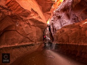
Water
Often, the canyon will only hold water to knee deep. However, after storms it can hold much more. Be aware of recent weather trends in the area and plan accordingly.
Drinking water can sometimes be found be purifying occasional seeps in Little Death Hollow.
Anchor Conditions
Natural anchors are abundant. Leave No Trace ethics apply.
Gear Recommendations
Helmet
Pads – Knee, elbow
Old clothes
Gloves
Daypack
3-4 Liters of water.
Flash Flood Danger: Low
The Exit
The confluence of Sad Cow and Little Death Hollow is not always obvious when descending the canyon. Pay close attention when the canyon widens, and you reach the confluence. Turn left and travel the roughly 4.5 miles back to the trailhead and your car.
Red Tape
BLM Land: Sad Cow Disease is located in Grand Staircase Escalante National Monument, and currently there are no access permits or applications required for day hikes. Permits are required only for overnight backpacking trips. There are, however, group size limits. The area in which this canyon is located has a group size limit of 12.
http://www.blm.gov/ut/st/en/fo/grand_staircase-escalante/Recreation/group_size.html
Most slot canyons are found on public lands managed by the US Government, although a few can be found on private lands. The US Forest Service, the Bureau of Land Management, and the National Park Service manage these lands. Each area tends to have unique management issues. As a result, there is not a uniform set of rules governing our use of these lands. For current issues related to canyoneering access, please visit www.americancanyoneers.org .