Fivemile has officially been closed today until August 31st.
“Due to special resource management concerns, Fivemile Wash is closed to hiking/canyoneering from the head of the wash to two miles downstream in the drainage. This closure will remain in effect until August 31, 2015.
Closure is in accordance with 36 CFR 1.5 (a)(1)”
I will not commit any more than above. This is just a notification for the Canyoneering Community and is normally an annual closure.
CRNPRES
Yes 2015, sorry I copied the wrong signage document. Maps correct.
Ram
confirming that the Cottonwood-5 Mile loop comes in below the closure. Best to do in March, April or October anyway.
How was quandary. TR to share?
CRNPRES
I have never done the Cottonwood – 5 mile loop so cannot confirm that. Always the thru route for me.
Quandary – wet and conquered with a few pack tosses in swimming keepers.
ratagonia
Thanks Rick.
Tom
Rick Demarest
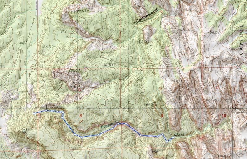
I just spoke with Terry Fisk, Chief of Resource Management & Science at CRNP. The decision to close Fivemile Wash was made yesterday and continues to August 31, 2015. This is an annual closure for ‘sensitive raptor habit’ (Owls). http://www.americancanyoneers.org/access-capitol-reef/
The closure is from the “Crest head of Fivemile Wash down canyon for 2 miles”. On a topo I think it would be something like this:
Mountaineer
I think they close it every year at this time, 2015? Owl habitat. I was lucky enough to go through last year before the closure, and got some great pics of at least one owl in there.
Iceaxe
2013?
Ram
Thank you for the information. I am trying to think how much someone would have to pay me to go to that canyon between today and the end of August. Might be just a tad hot! LOL! That said if I read the above right this involves the Wingate and Boxelder Narrows section of the canyon. While I have no intention to venture there now, I do have a route that enters mid canyon and know others have used this route too. I suspect it is safely below the closure. Could the park provide a map of the boundaries of the closure area? Can we assume that it is 2 “air” miles down from the top of the wash? Sorry to make work for you folks. Think it would be helpful and wise to do so.
Ram
CRNPRES
Heading to Quandary right now. I will look for a map for you guys probably not until Saturday
Ram
Safe passage and enjoy