It is hot out, this year. WAY hotter than normal, so how can Fat Man’s be made reasonable? With a somewhat unreasonable start time of 6:23 am, of course, though just barely. That may not SEEM all that early, but considering I signed on at 10 pm the night before, it certainly felt pretty early. TeamCanyon was Katie Duncan, Heidi Thorne, Amanda Jessop and me; all members of the ZAC Team. This was Katie’s first technical canyon.
In addition to a fine canyon and fine company, I was looking to update my Fat Man’s description for the website and upcoming 2nd edition of the guidebook. The current description is OK, but very skimpy. Perhaps this should be highlighted as a beginner-friendly canyon, which calls for a much more thorough description. Plus a bunch more pictures – check. And I really otta make it down to Labyrinth Falls so that can be in the book.
At this early hour, Zion is very pleasant, like a walk in the Park. We sauntered up toward Checkerboard pass in the cool of the shade. MANY social side-trails are available – and most lead to unpleasant places. Certainly most are entirely unnecessary. The only significant obstacle in the approach canyon is a short chimney easily bypassed by a short trail. I smell an American Canyoneers service project sometime in the fall…
Made it to the pass without too much pain, out the other side and eventually into the sun. Past the big white buttress, then eventually to the edge of Misery Canyon. Big slickrock downclimb to get to the bottom of the canyon just below the string-of-pearls potholes. We sauntered down to the first rappel, with that old bolt I thought was suspect in Y2K with Brian Cabe was still there! WAS a tree with a sling around it up and right, but we chose to rig up a convenient rock as an anchor, rather than climb around to the tree.
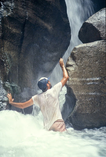
A delightful canyon at a delightful pace. We weren’t in a hurry, as we knew we would siesta at the East Fork until 5 pm, so we were able to enjoy the canyon at a very relaxed pace. Arches, little downclimbs, short rappels – Fat Man’s is just a FUN canyon with minimal angst and effort, except for the hike out. We replaced the ‘fixed rope’ at the swing-around room; tried to avoid cold water in a couple of places (no more than waist deep); and rebuilt a few not-so-secure anchors. Near the junction, we walked around what looked like a nice section, because it was just too darn hot to build anchors out there in the sun. Maybe if we had brought an etrier…
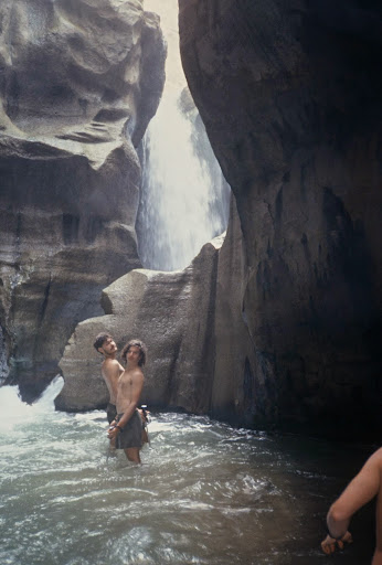
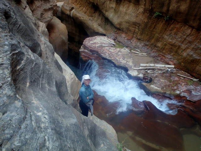
Another rap or two, a fun slide and we arrived at the coolest place, the final grotto, including a little downclimb into the two-arch room. Great light, we had at two p.m.
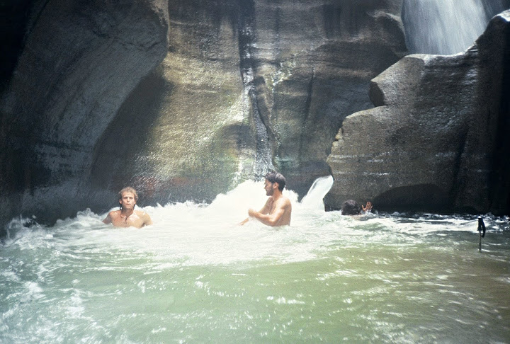
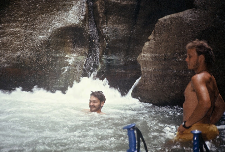
Pulled out the tripod for a couple of semi-posed shots in the East Fork, then found a nice place to chill out for a bit. After a short nap, we traipsed down to the Powell Plaque and dumped our packs, near but not IN the poison ivy, and headed downstream for Labyrinth Falls. In the year 2000, Brian Cabe and I had not had time to go all the way to the falls, but this time, we had plenty. We downclimbed and waded downcanyon to where we could tell the falls was just around the corner. How to get there? There was a bit too much water to go down the watercourse or, at least, we KNEW we could not wade or swim back up. A bit of a traverse using gringo-chipped holds led us to some ledges that allow a view of the falls, pretty much. We explored around, but found no way to get down below the falls for pictures, without a rope…
Amanda was more adventurous. With us looking on, she downclimbed and downslid to the ledges right next to where the water plunges over the edge. Took a couple tries to find the right line to get back up – had us a tad concerned there for a moment!
We all immensely enjoyed the beauty of the East Fork. All too soon, the time to brave the heat above was at hand. We watered up, shouldered the packs and started up the exit, gasping at the oven-like heat in a few places. On and on it goes – cairns, signs of passage, short steep steps… 1600 feet of gain, but at least the sun is often at your back. What a grunt. I thought we moved pretty well, still 3-1/4 hours back to the car.
More photos, pretty much the same text on the Latest Rave.
Featured Image for the Homepage
Mountaineer
We found the traverse as described, sketchy…
There is a fairly good sized tree up there you could get to, high up on the traverse, for a rap and ascend back out. Getting to that tree is also exposed. I didn’t see any other natural anchor options, but maybe? Furthermore, there are 3-4 edges the rope would travel over adding challenge to the ascent.
Amazing Powell and company made it over, and I’m sure with quite a bit of gear.
hank moon
There WAS a bolt some years back, but one of those bent rebar thingies. Maybe something good…maybe something bad…we’ll never know.
ratagonia
with sticky shoes, we did not find the traverse difficult – just required focus. Seems like there was a bolt there that could be used for a belay.
Tom
Ram
I didn’t see a bolt, but I wasn’t looking for one and did not go across it either, not in the last 20 years or so. We did cross it with full packs and no sticky shoes back in the 80’s. I am sure some kind of line can be managed
Tyler
We did Fat Man’s a month earlier in May last year (about to post a video of our little adventure) and my wife and I tried to get down to Labrynth, but turned around at the big logjam falls because we didn’t trust we could get back up from there without a rope (left the packs back at the powell plaque).
As I was editing my video footage I was reminded how beautiful that canyon is. I can’t believe I had forgotten in less than a year.
Ram
The falls has quite the hydraulics even in low water, which the below pictures were taken in. We found it impossible to get up to the inner waterfall room. I can’t find the picture where I was stemming just outside the room, but it appeared potentially deadly in the upper room proper. I did find one picture of me starting to stem up there. Here are 4 photos of below the falls and one random youtube video from above. The pictures are from July 1988 when it was legal to descend out to route 9 at the Trees Ranch
Between the upper and lower Waterfall rooms
From the entry into the lower room
Lower room. it was a challenge getting to the stem up
random video looking down in
Brian in SLC
Rough lookin’ crew there, Tom. Hope your T count survived…ha ha…
No flower shots…hmm….interesting…
ratagonia
Well, there was one…
Fragrant Sand Verbana… fragrant first thing in the morning.
T
Mountaineer
About how far (time or distance) was it to the Powell Plaque after the grotto section or East Fork Virgin River junction? To the falls?
Mountaineer
Answered. Also well shown in the book Zion Canyoneering. Not far, ~1/3 mile or less…Labyrinth falls is past the park boundary and after the first major bend north than south.
ratagonia
10-15 minutes to the Powell Plaque and a wonderful poison ivy garden. About an hour round trip down to overlooking Lab Falls. Next time I would bring a rope and rope-climbing gear to visit the bottom of the falls.
Tom
Bootboy
The canyon is technically closed BELOW labyrinth falls, right? I like the idea of rapping and ascending back up.
LNT
ratagonia
The canyon is closed below the Navajo Sandstone. The falls are the last gasp of the Navajo, however, there are certainly some pieces of Navajo below the falls, so walking around below the falls is OK, but proceeding downcanyon from there is not.
Tom
Bootboy
Capisce
LNT
Ram
So they base the rule on the sandstone layer? Interesting. If one wants to get to where my pictures are above and it is legal to do so, here is the non jugging route.
From the height where this picture is taken…note the falls below Jenny
At the level the picture is taken, there is a ledge heading downcanyon (left) just beyond the upper left edge of the picture. For about 8-10 the ledge ends and becomes a slab, but with small features. This is the crux traverse. It is at most class 4, not hard, but it is intimidating and exposed. After crossing it (easier coming back BTW), hop up a ledge or two, to a flat bench. Follow the bench about a quarter of a mile until a class 3+ weakness becomes apparent below you. Drop to the stream and head upstream to the falls. Reverse the route, to get back.
delenius
Interesting. I am doing Fat Man’s next weekend. Is it possible to set up a fixed line or some other kind of protection for this traverse?
Doug Murray
Thanks, Tom.
A couple of us did it about 10 days earlier. We debated on checking out the falls, but didn’t. We’ll have to take a look next time around.
Kuenn
As Rod Stewart put it …
Some guys have all the luck
Some guys have all the pain
Thinking I know which category Tom fits in…gotta be the name, or the shoes.
Nice report.
Bootboy
Awesome!
How do I get your job Tom? Adventuring with a group of lovely young ladies… Hopefully doing this canyon on Tuesday with a lovely young lady of my own.
Cheers